individual independent project | 2021
created for use by Ferguson Township using my parametric neighborhood generator
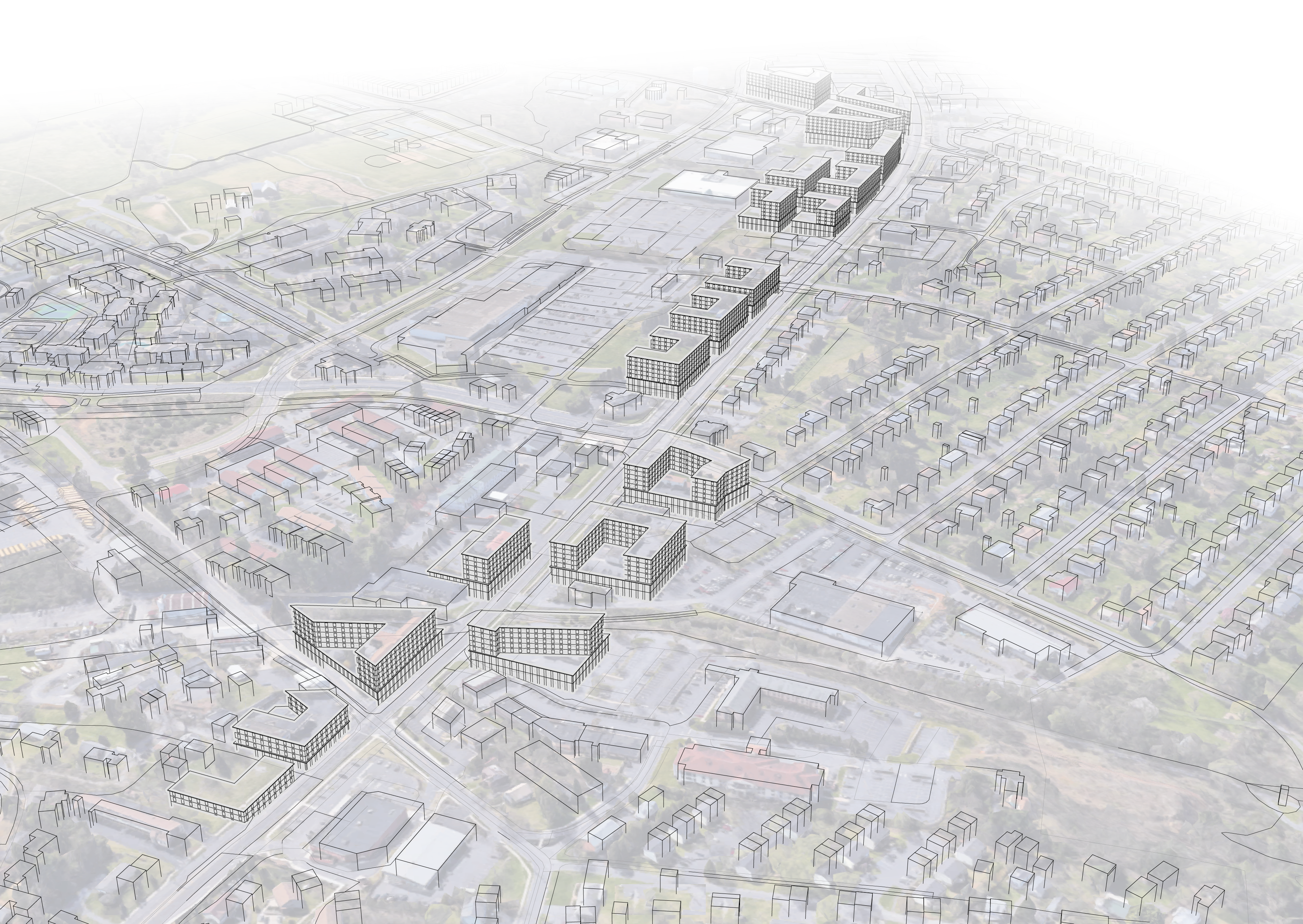
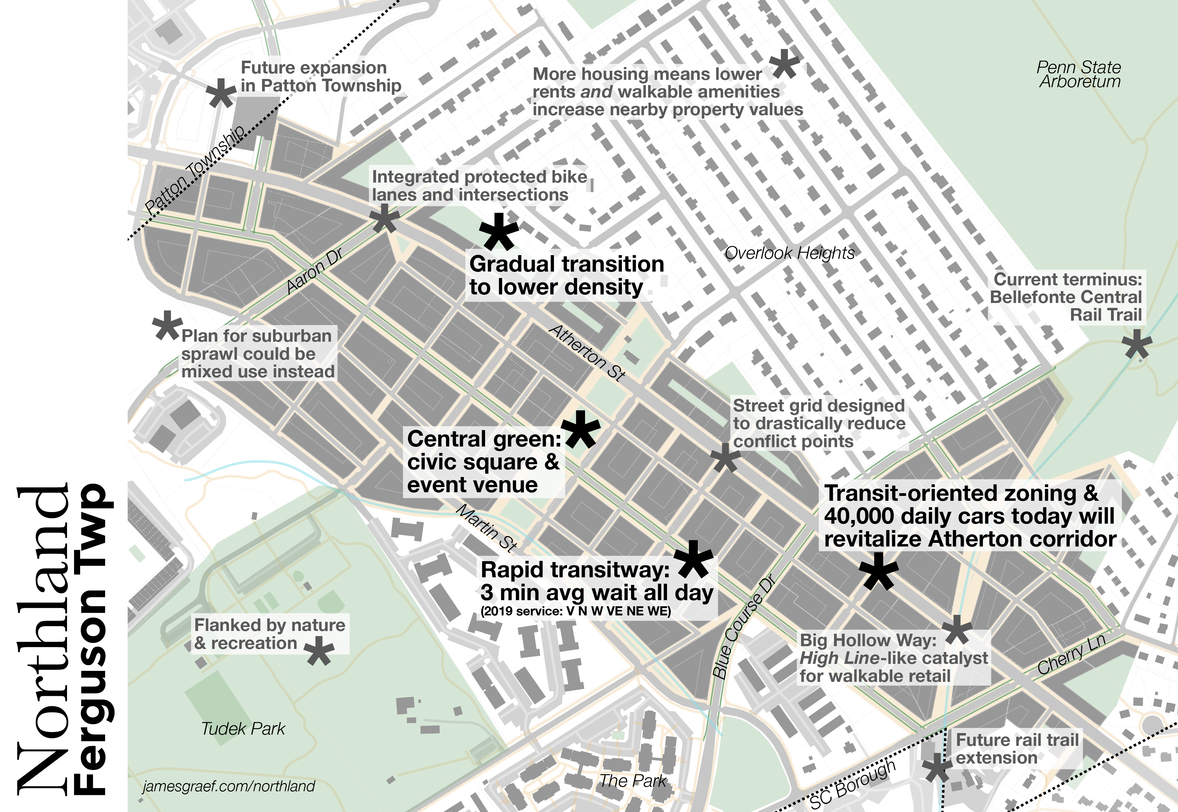
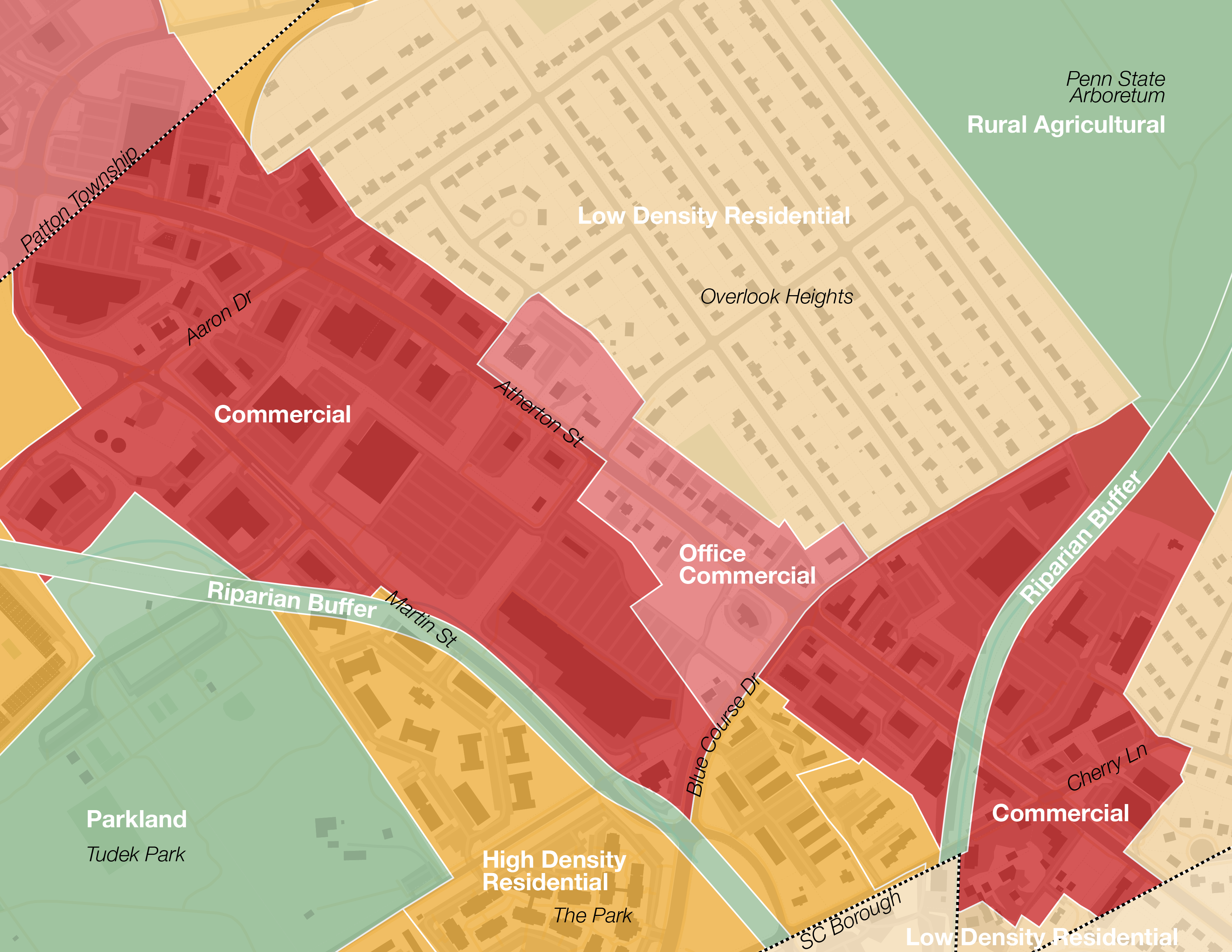
Ferguson Township’s section of North Atherton St is lagging behind. Strip mall and suburban commercial investment seems to have shifted focus to Patton Township, and some developments struggle to retain retail tenants. At the same time, this section of Atherton St sees over 40,000 cars per day: it’s the most vehicle-traveled street in the region by far. In addition, buses on the corridor are so frequent the average wait is 3 minutes or better all day.1 Ferguson Township has the potential to create a thriving and sustainable transit-oriented, walkable, mixed-use town center with retail space for local small businesses and abundant attainable housing.
Three steps to implementation:
1Rezone the study area to allow mixed-use, walkable development which gradually transitions to lower density uses at its edges. Ferguson Township’s Terraced Streetscape District zoning regulations should inform this rezoning, though some revisions will create better urban spaces and will encourage more investment more quickly:
- Reduced or eliminated parking minimums: average waits for transit are an order of magnitude shorter2 on N Atherton St than W College Ave and mandatory parking increases construction costs and rents by 17%—likely a major barrier to investment in the current Terraced Streetscape District. View cities, like Ithaca, NY and Lancaster, PA, which have eliminated parking minimums to create better urban spaces
- Allowing for shared or public parking decks serving multiple buildings and/or leniency for parking above ground when facing alleys or less-traveled streets
- Increased impervious coverage allowances, offset by intentionally designed public greenspaces and integration of nature on pedestrian streets like Big Hollow Way
- Number of stories restrictions instead of strict height requirements allowing taller ground-floor retail
- Requirements for retail facing Atherton St—3 times more traffic on N Atherton St than W College Ave3 means retail spaces are far more viable,—the future transitway, Big Hollow Way, and the central green; looser requirements elsewhere
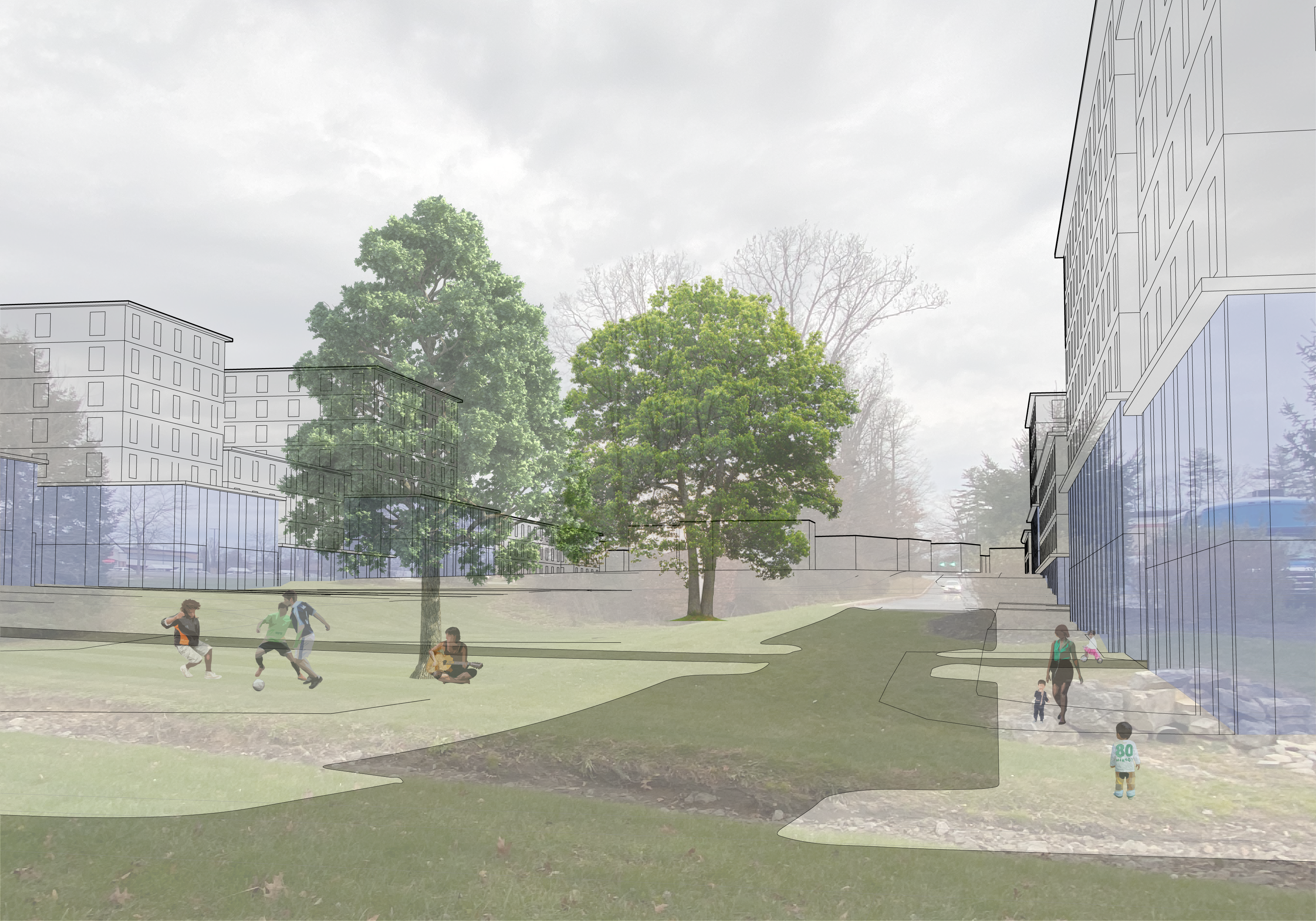
Intentionally designed public green spaces—central green and integrated stream bed,—rather than impervious coverage restrictions, are better for recreation and the environment
2Update the township’s official map to include a street grid across the study area. Map updates must occur before any development occurs so new development is not built where streets would be optimal. Newly built parts of the street grid should connect to existing parking lots until those parking lots are developed.
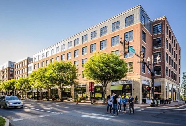
College Row near Franklin & Marshall College: Two walkable, dense buildings catalyzing more adjacent walkable development
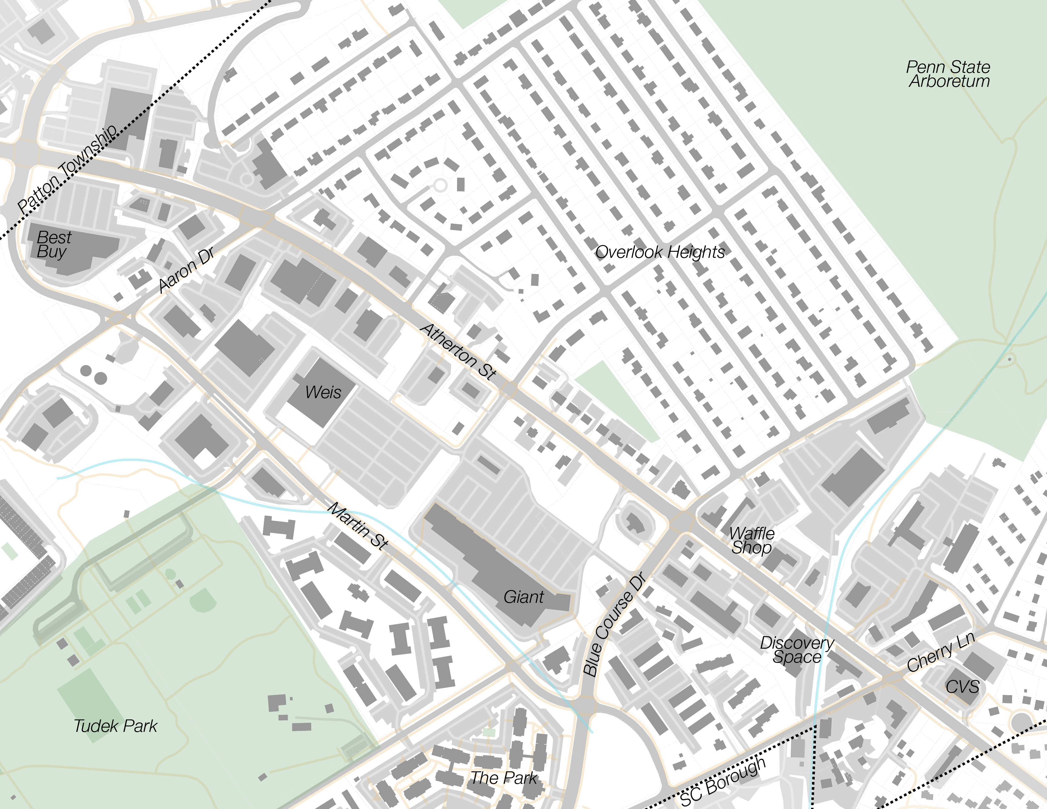
Existing study area 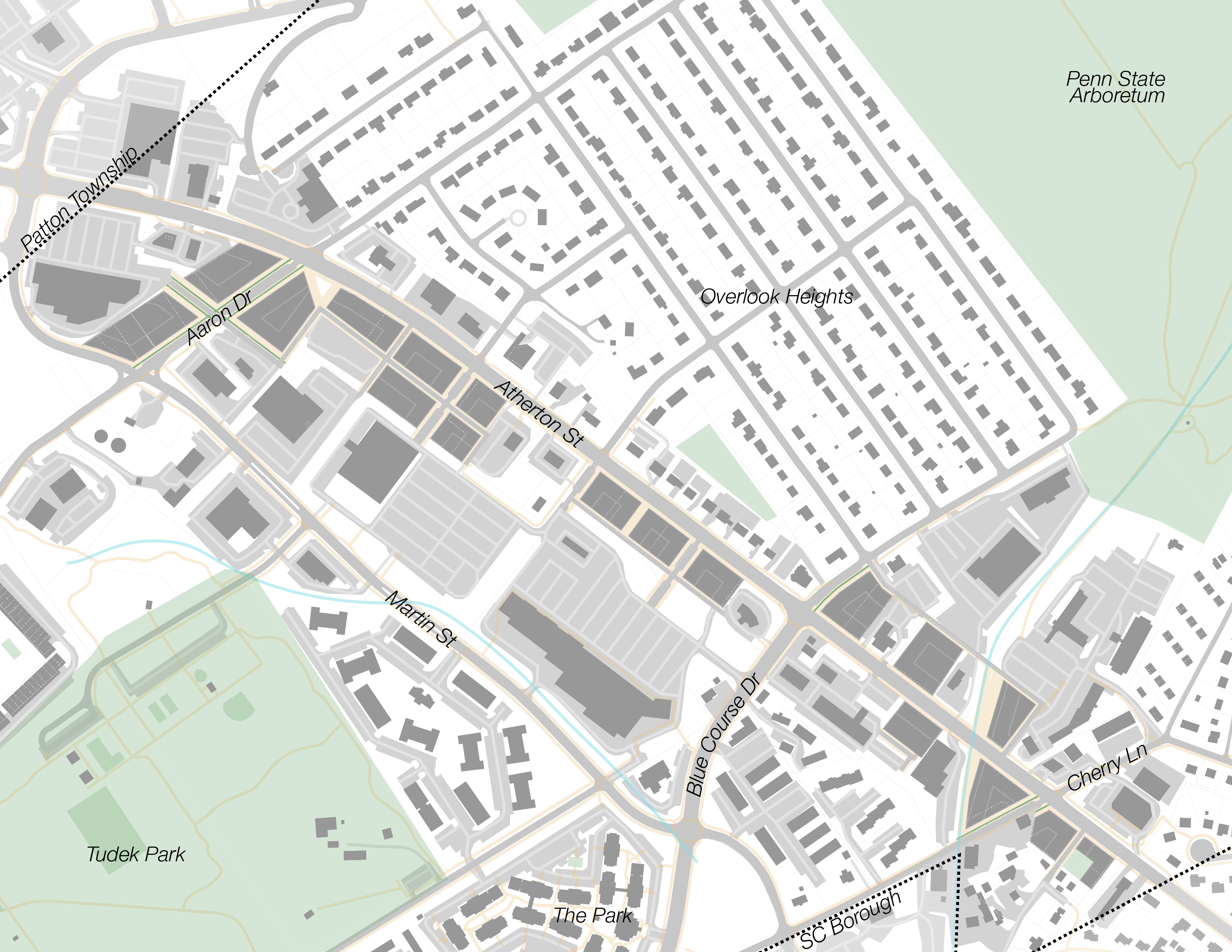
Development along pilot corridor 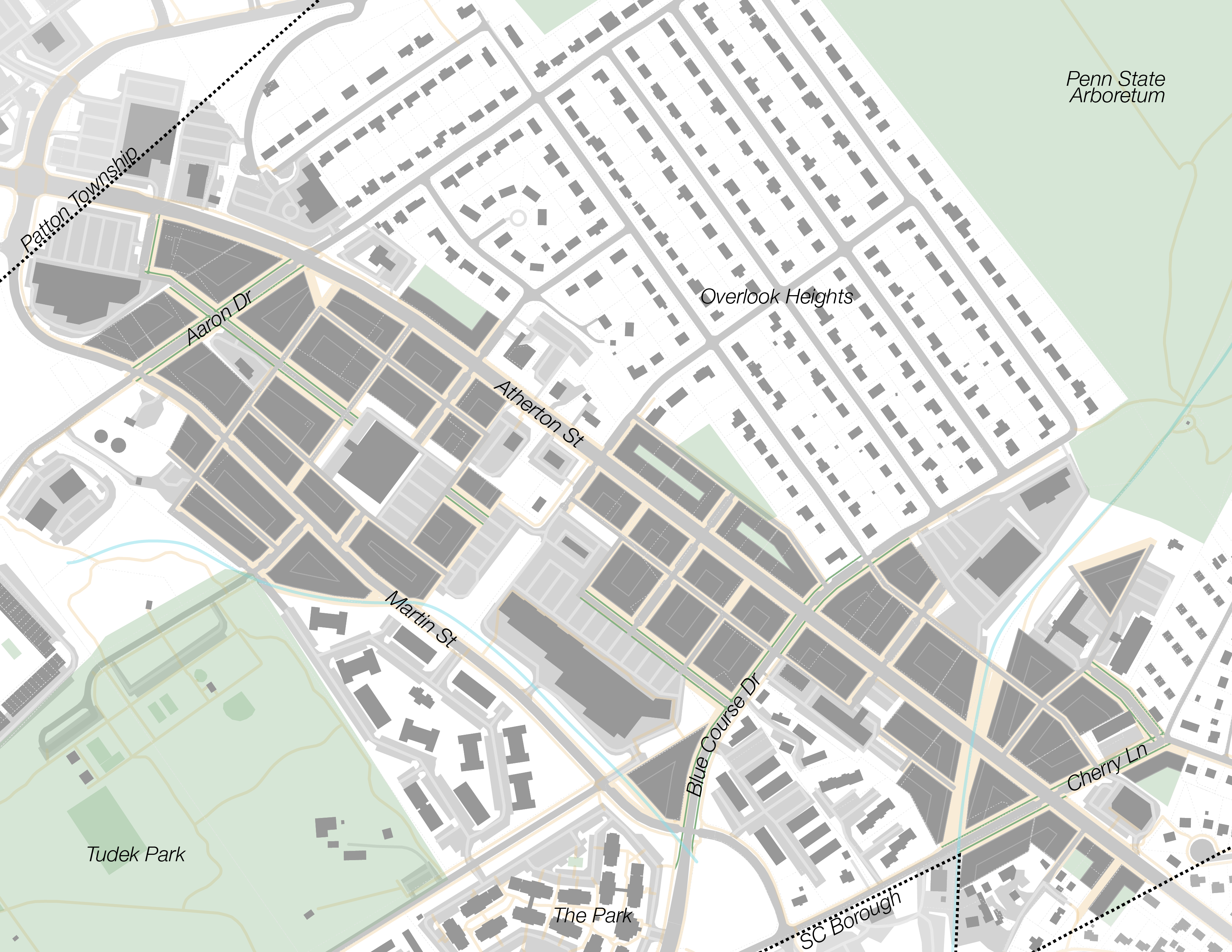
Partial build-out retaining most high-value buildings 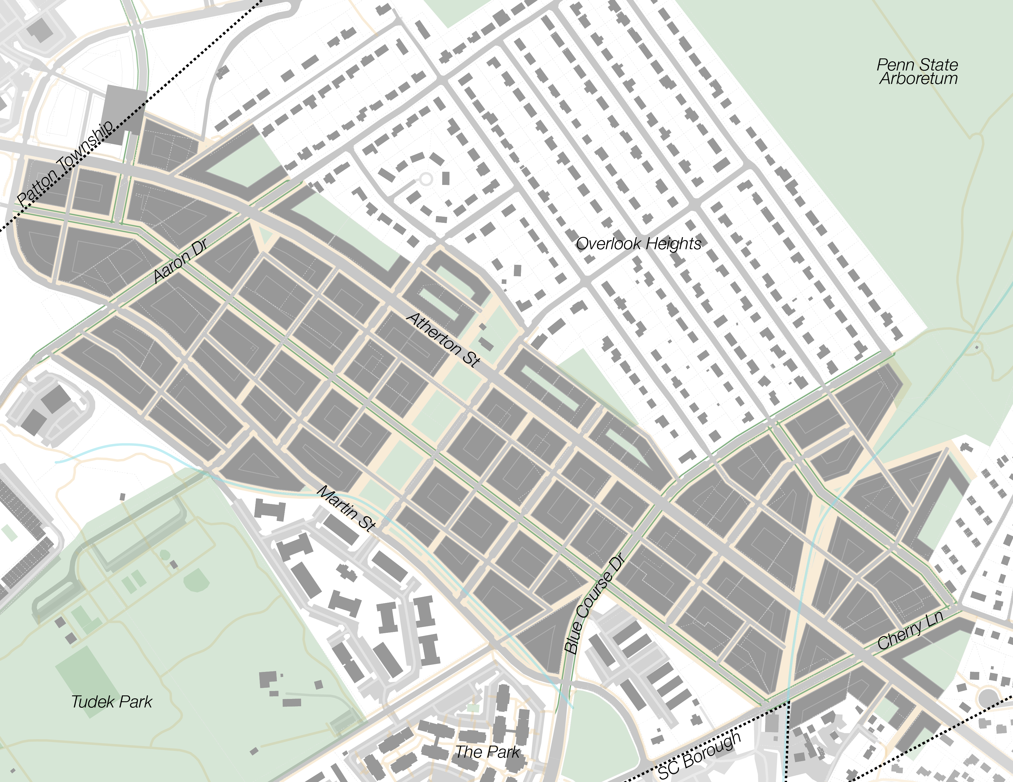
Fully realized Northland


3Fund new street and utility construction as development occurs. Rights to higher density development may be enough to extract funding for or construction of required infrastructure from developers. State College Borough uses conditional approval of signature developments downtown to extract new sidewalks and other improved infrastructure. Alternatively, funding instruments like tax increment financing may be required. Increased tax revenue from higher allowable density and increased street frontage should more than pay for street and utility maintenance.
Buildings and residents

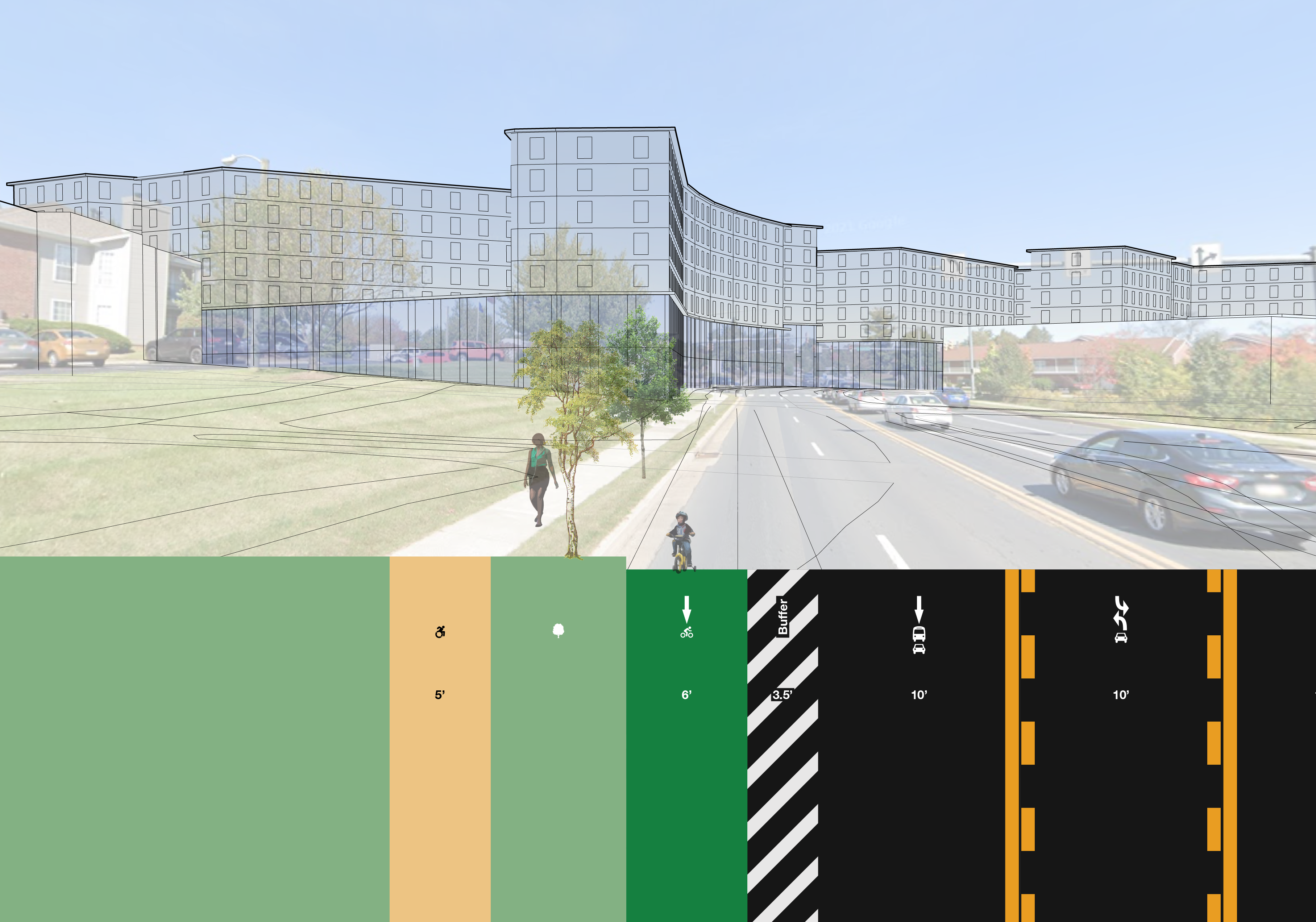
Atherton St at North Hills Pl with activated 17 ft wide sidewalk and highly-visible retail space
Northland has the potential to create thousands of new housing units—enough attainable housing for decades of sustainable, walkable growth—without dense towers or sprawl encroaching on rural and wilderness land.4
This proposal designates most of Northland as mid-rise mixed use: up to 5 residential stories above a 1- or 2-floor podium hosting retail and commercial space, lobbies and amenity space for residential units above, and parking. Where the study area approaches low-density residential neighborhoods, low-rise mixed use areas would allow 3 residential stories above a podium, and transitional residential areas would allow 3 stories without a podium.
Existing zoning 
Zoning for a pilot corridor 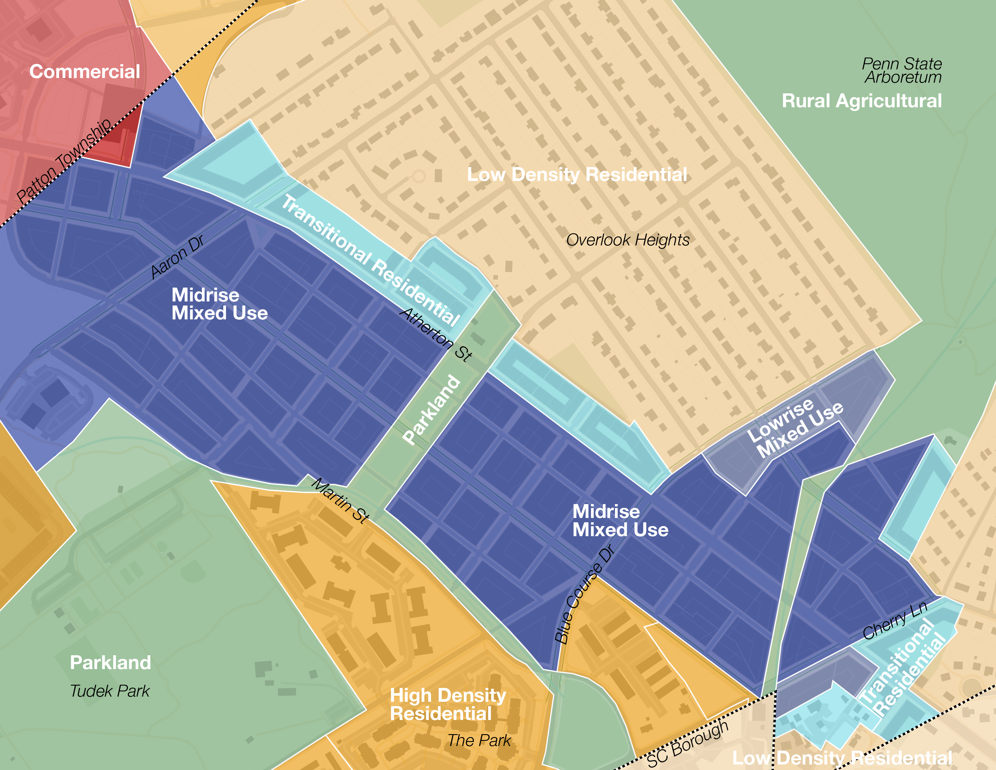
Zoning for a fully realized Northland


The average proposed building has 4 residential floors5 and a residential floor area ratio (FAR) of 2.4.6 Increased housing supply will result in more affordable rents while new walkable amenities will increase property values in nearby neighborhoods. The central green could be used for family picnics and community festivals, and the High Line-inspired Big Hollow Way could host an extented Bellefonte Central Rail Trail, small businesses, and local restaurants, with a well-landscaped stream bed as its central spine. See what streets designed to integrate nature could look like. Northland could offer a downtown-like urban, walkable, transit-rich place to live with lower rents and fewer students than downtown due to its remove from campus.
Rapid transitway: a virtuous cycle
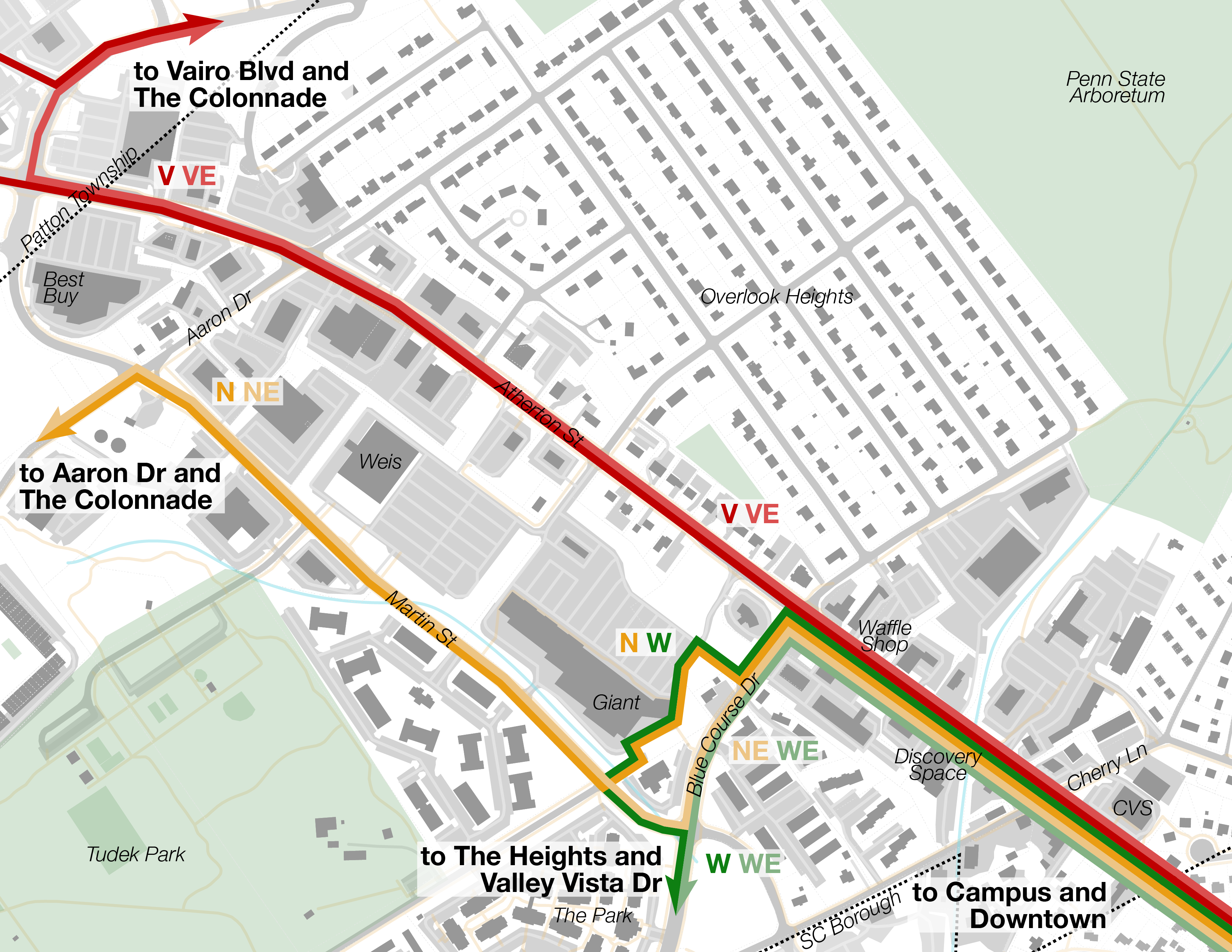
Existing transit routes 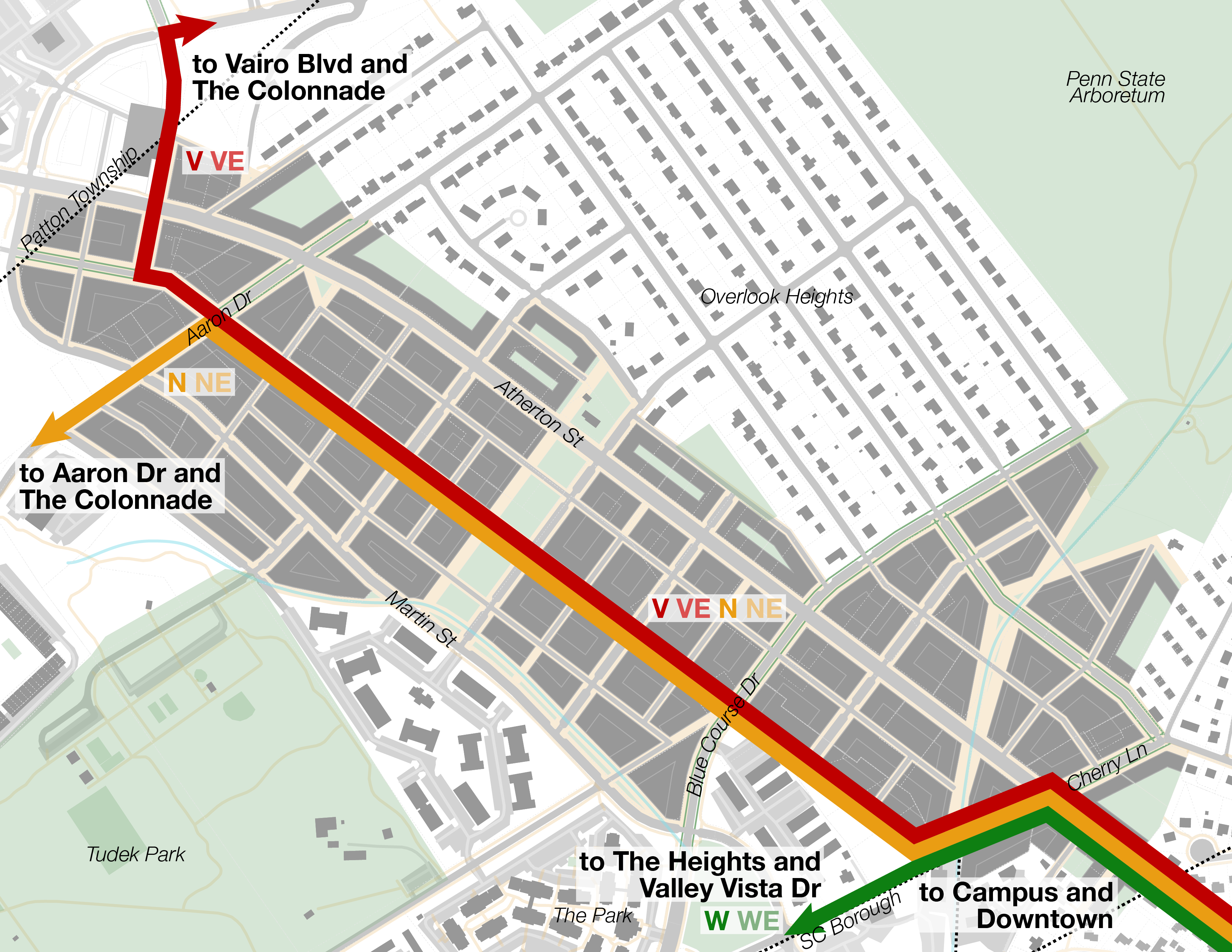
Higher-frequency service on the new transitway
N Atherton St sees 10,500 transit riders every weekday and a bus every 3.5 or 4.5 minutes on average all day.1 Northland would benefit from this incredible frequency and CATA would benefit from increased ridership—as many as 26,000 new weekday rides at full build-out.7 More than tripling ridership could warrant a bus every two minutes or better8 and serious consideration of rapid transit on the corridor.9
Bike infrastructure: missing links
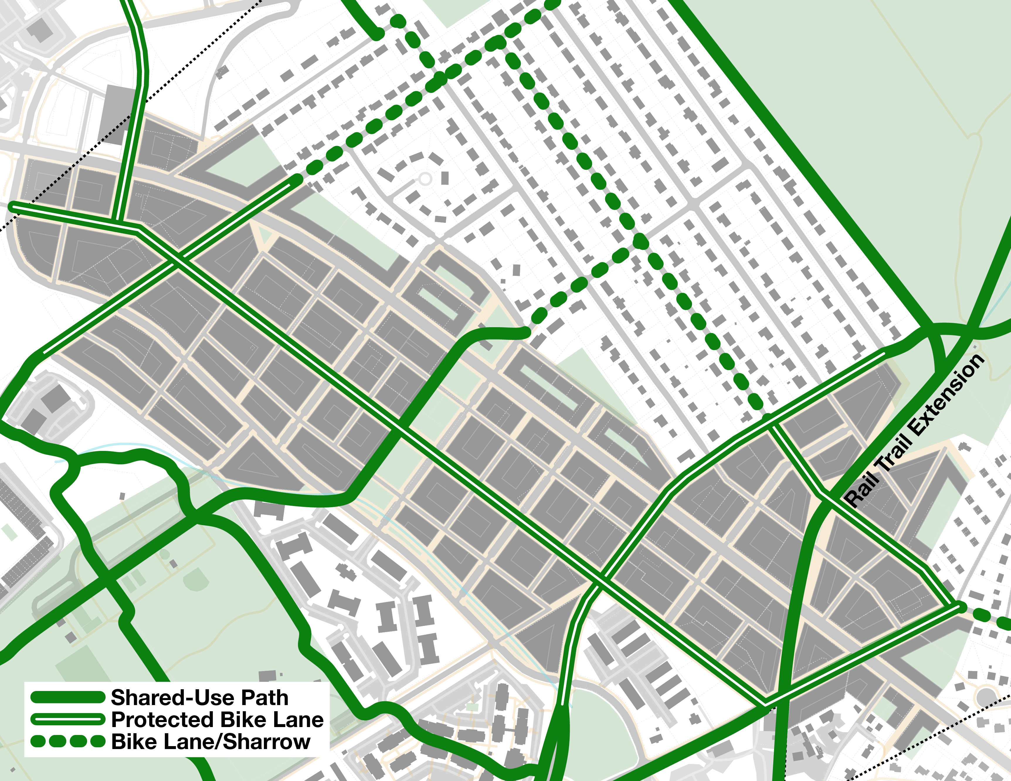
Ferguson Township is actively working to install bicycle facilities in the study area, where none currently exist, to connect shared-use paths and rail trails radiating in every direction. Developers could provide funding for or construct street improvements like protected bike lanes adjacent to their new buildings. Protected bike lanes and protected intersections—protected from cars with buffer space, bollards or curbs, and often parallel parking—are the bicycle infrastructure solution in urban environments. They:
- protect bikes from cars, especially while turning at intersections
- use valuable street space most efficiently
- separate bikes from slower pedestrians unlike shared-use paths
Depending significantly on how the township plans to deal with snow, protected bike lanes can be installed at sidewalk level, street level, or between. Painted bike lanes or sharrows are acceptable on low-volume neighborhood streets but protected or buffered alternatives should be considered based on vehicle and bike traffic volumes and steep slopes.
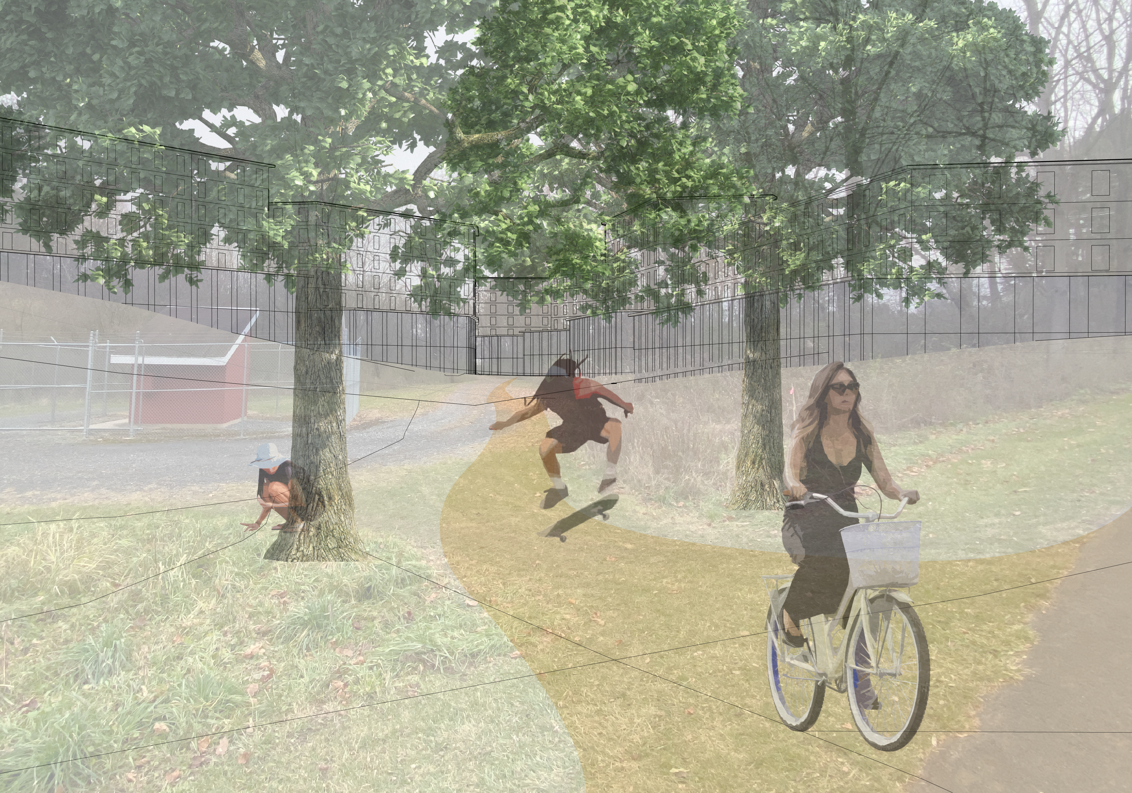
View of Big Hollow Way showing extended Bellefonte Central Rail Trail
Vehicle safety
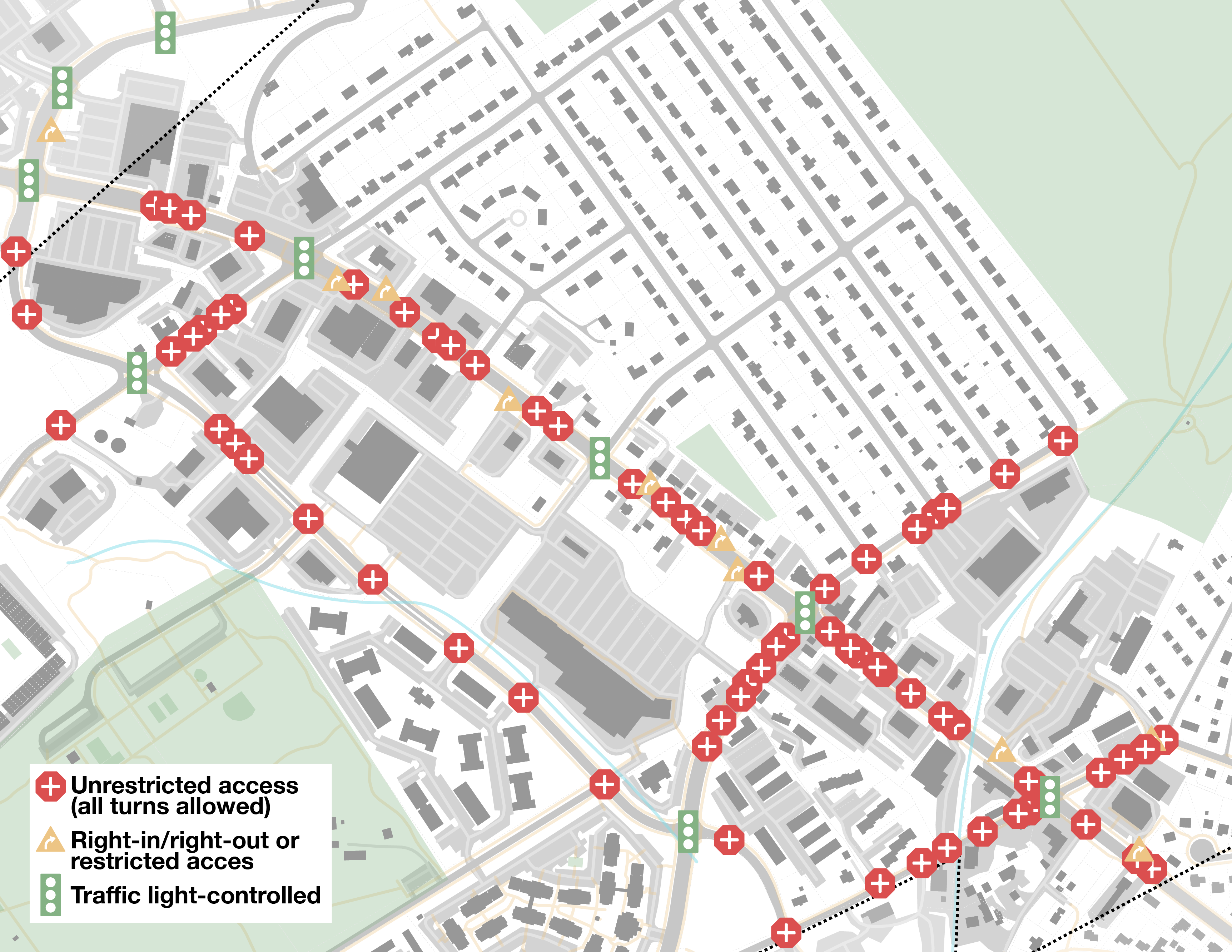
Existing intersection conditions 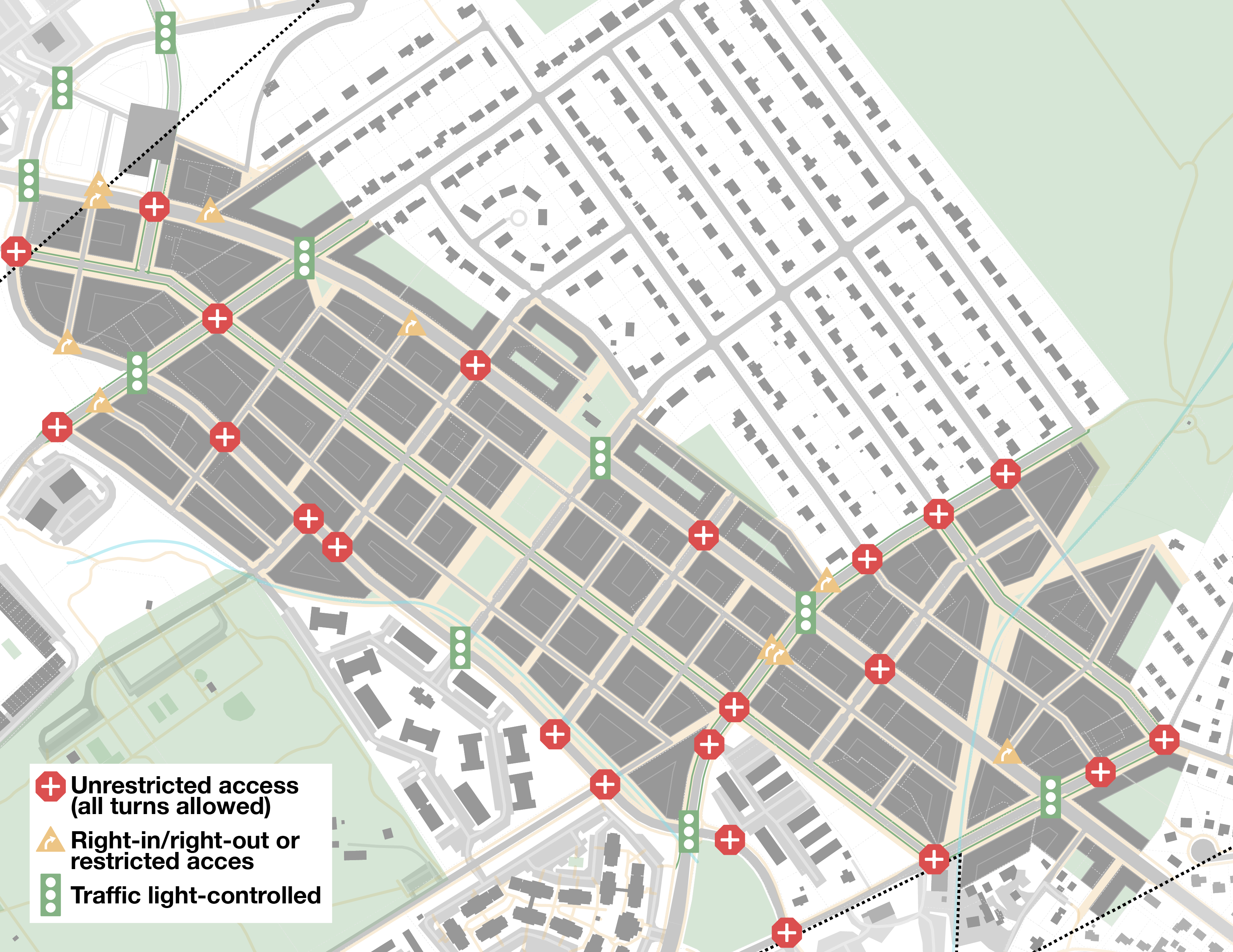
Proposed intersection conditions


This proposal would eliminate a substantial proportion of the study area’s intersections at arterials with unrestricted access. Intersections with unrestricted access are some of the most dangerous places in a road network, especially on wide arterials like Atherton St. The proposed street grid is designed with pedestrianized streets to minimize these unsafe intersections. Remaining unrestricted intersections on Atherton might function better with traffic lights or turning restrictions, to be studied further during implementation.
Blue Course Dr approaching Martin St showing one-way protected bike lane

Existing study area 
Pilot corridor 
Partial build out 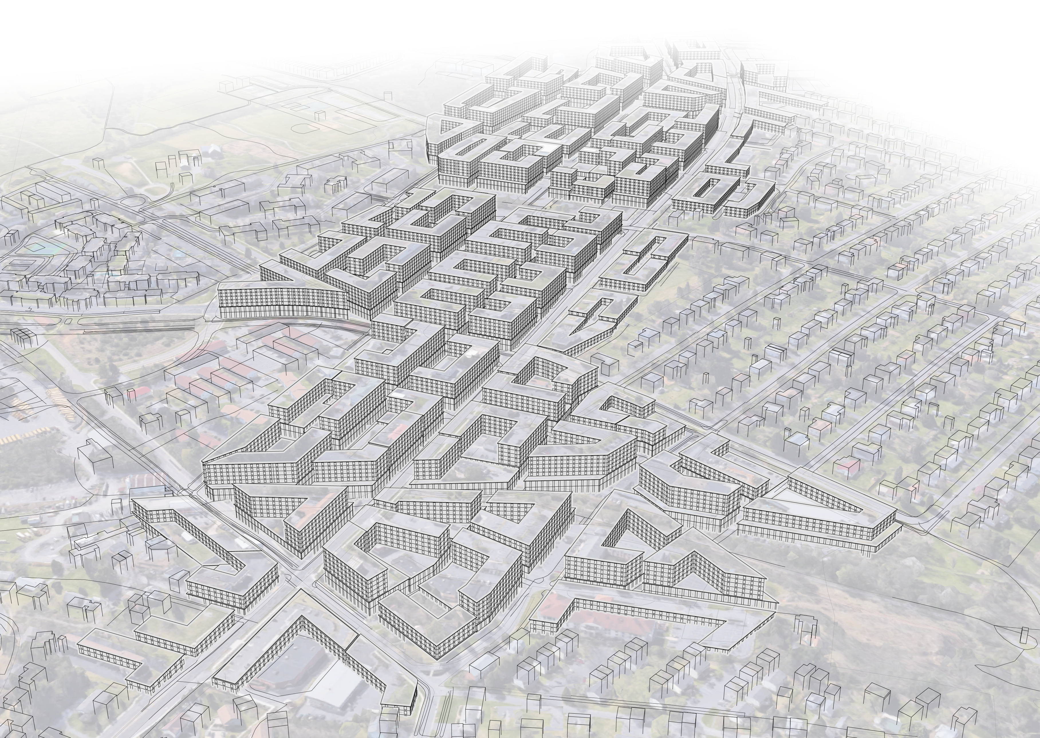
Fully realized Northland
This proposal is an update to a project I completed in 2017: North Atherton Redevelopment.
Proposal plans and visualizations were created using my parametric neighborhood generator. Learn more about how it works.
Footnotes
1 A fully realized Northland would justify even higher frequencies.8 Calculations assume express buses serve the study area, unlike today—articulated buses reducing crowding and increased ridership in the study area due to proposed new development justify the change. Due to temporary post-pandemic recovery and staffing shortages, Fall 2021 weekday peak is identical to 2019 weekday daytime; VE, NE, WE do not operate off-peak.
| Location | Avg Headway | Existing Avg Wait | Optimal Avg Wait* | Routes every 20 min | Routes every 40 min | ||
|---|---|---|---|---|---|---|---|
| 2019 | weekday peak | Atherton at Cherry | 3 min 38 sec | 2 min 38 sec | 1 min 49 sec | V, N, VE, NE, WE | W |
| Atherton + Martin at Aaron | 5 min 0 sec | 5 min 12 sec | 2 min 30 sec | V, N, VE, NE | |||
| weekday daytime | Atherton at Cherry | 4 min 27 sec | 3 min 2 sec | 2 min 13 sec | VE, NE, WE | V, N, W | |
| Atherton + Martin at Aaron | 6 min 40 sec | 6 min 0 sec | 3 min 20 sec | VE, NE | V, N | ||
| Built-out Northland | est. weekday peak8 | Transitway at Aaron | 1 min 21 sec | 41 sec | 44.4 buses per hour | ||
| est. weekday daytime8 | Transitway at Aaron | 1 min 45 sec | 52 sec | 34.4 buses per hour |
* Average wait would be significantly shorter (half of average headway) if buses on different routes had evenly distributed headways (eg. 4 minutes between each bus instead of a gap of 2 minutes then 6 minutes)
2 9.89 times longer average wait for a bus on W College than on Atherton:
Atherton St at Cherry Ln 2019 weekday daytime service: 3 min 2 sec avg wait1
W College Ave at Butz St 2019 weekday daytime service: K hourly: 30 min avg wait
3 3.07 times more vehicle traffic on Atherton St than W College:
Atherton St at Blue Course Dr: 40,470 AADT Feb 2019, PennDOT
College Ave at S Butz St: 13,189 AADT Feb 2019, PennDOT
4 Northland could support all the Centre Region’s residential unit growth for an estimated 21.1 years and all the region’s non-residential growth for an estimated 23.1 years. Learn about the Centre Region’s strides toward attainable housing.
| Forecasted Growth 2009-2040 | Residential Units | Non-Residential Sq Ft |
|---|---|---|
| Ferguson Township | 2,863 | 1,005,224 |
| State College Bororugh | 1,095 | 1,070,955 |
| Patton Township | 2,404 | 1,357,200 |
| College Township | 1,466 | 3,133,236 |
| Harris Township | 983 | 109,000 |
| Halfmoon Township | 467 | 14,000 |
| Centre Region Total | 9,278 | 6,689,615 |
| Northland (2022 to full build-out) | 6,326 | 4,993,100* |
* Hotel space is included in non-residential sq ft but will require marginally less podium sq ft and marginally reduce number of residential units in Northland. Heavy industrial uses will not be compatible with land use in Northland. Some space may be used for parking depending on zoning regulations.
| Northland | |
|---|---|
| total number of buildings | 97 |
| total residential space† | 8,497,600 gross sq ft |
| number of units | 6,326 |
| avg per unit‡ | 1,343 gross sq ft |
| number of beds | 21,104 |
| avg per bed‡ | 403 gross sq ft |
† Total sq ft excluding podiums which are expected to house parking, amenity, lobby, retail, and commercial space. Massing above podiums determined by assigning 55 ft wide wings to building sides facing the widest streets (including their setbacks) until an optimal coverage ratio is met.
‡ Avg gross sq ft per unit and bed calculated from plans of recent dense, walkable development in the region with wildly different unit layouts. Student housing is a reasonable proxy for apartments made for families because of the high number of beds per unit.
| Reference developments | ||
|---|---|---|
| 132 Garner St: SC Borough Planning Commission 11/30/17 | total residential space | 258,245 sq ft |
| total circulation/service space | 73,536 sq ft | |
| units range from studio to 5 bedroom | ||
| number of units | 247 | |
| avg per unit | 1,343 gross sq ft | |
| number of beds | 824 | |
| avg per bed | 403 gross sq ft | |
| avg number of beds per unit | 3.34 beds | |
| Core Spaces Pugh St: SC Borough Planning Commission 9/23/21 | total residential space | 208,250 |
| total common areas | 7,173 | |
| avg per unit | 1,252 gross sq ft |
Reasons to think 21,104 people is an underestimate:
- residential FAR is likely to be higher than what is shown in this proposal, based on new dense, walkable development in the region
- 132 Garner St circulation and service space includes some spaces in the podium, meaning gross square footages are higher when analyzing only the floors above the podium
- more developers may build the maximum number of floors allowed by the proposed regulations than shown5
- some bedrooms will accomodate more than one person
Reasons to think 21,104 people is an overestimate:
- gross square footage per unit is likely to be higher in Northland than in downtown State College because of lower land costs
- 132 Garner St includes some amenity space above the podium, whereas this proposal assumes new buildings in Northland do not because of lower demand for commercial space than downtown. If amenity space is provided above the podium, there may be less space for residential units in each building
- some buildings are likely to be hotels rather than apartments or condominiums
- some bedrooms will be used as offices or otherwise not serve as bedrooms
About twenty residential units have the potential to be redeveloped early in this proposal’s timeline. All existing residential units in the study area:
- estimated 19 units flanking Cherry Ln at Atherton St in three buildings: likely to be some of the first redeveloped parcels
- estimated 14 units located on Blue Course Dr flanking the intersection with Johnson Terrace: likely to be redeveloped far in the future
- estimated 18 units located on Johnson Terrace: likely to be redeveloped far in the future
- estimated 36 units, 709 to 725 Cherry Ln: likely to be redeveloped far in the future
- 18 units under construction as part of 3-story mixed-use building on Cherry Ln: likely one of the last parcels to be redeveloped
5 This proposal generates some buildings with fewer floors than allowed by the proposed zoning regulations to account for development idiosyncrasies:
| 3 Res. Floors | 4 Res. Floors | 5 Res. Floors | Any Floors | |
|---|---|---|---|---|
| Transitional Residential | 14 buildings | prohibited | prohibited | 14 buildings |
| Low-Rise Mixed Use | 6 buildings | prohibited | prohibited | 6 buildings |
| Mid-Rise Mixed Use | 12 buildings | 19 buildings | 46 buildings | 77 buildings |
6 Average FAR calculated by multiplying number of floors by area of floor plate and dividing by lot size (assumed to be area inside build-to lines at edges of sidewalks).
| Residential Floors (non-podium) | Commercial Floors (podium) | Total | |
|---|---|---|---|
| Avg number of floors | 4.18 | 1.61 | 5.78 |
| Avg FAR | 2.44 | 1.49 | 3.93 |
| Total sq ft | 8,497,600 | 4,993,100 | 13,490,700 |
7 Estimated ridership based on daily rides per number of residents on the Vairo Blvd corridor.
| Routes | Weekday Ridership 2017 | Population Served | Avg Daily Trips per Resident | |
|---|---|---|---|---|
| Vairo Corridor | V, VE | 5,660.4 people | 4,536 people* | 1.25 trips |
| Existing N Atherton Corridor | V, N, W, VE, NE, WE, A, G | 10,523 people | ||
| Northland | 26,335 estimated | 21,104 beds4 | assumed 1.25 | |
| N Atherton + Northland | 36,859 estimated |
* Estimated. 2020 US Census data for census tracts 113.01 and 113.02: area bounded by Atherton St, Vairo Blvd, and Interstate 99.
8 Extrapolation from current Vairo Blvd service levels to the N Atherton corridor with 26,335 new daily rides7 from Northland residents:
| Weekday Peak Service | Weekday Daytime Service | |
|---|---|---|
| Additional buses justified by Northland | 27.9 | 20.9 |
| Total buses per hour with Northland | 44.4 | 34.4 |
| Headway between buses with Northland1 | 1 min 21 sec | 1 min 45 sec |
Economies of scale may make each bus more productive, though new riders from other new development to the west and from commercial space in Northland would increase need for capacity further. Higher frequencies would also encourage significantly higher ridership by dint of shorter waits.
9 Bus rapid transit is justified today on the Atherton St corridor, and will almost be a requirement by the time Northland approaches full build-out. Making the proposed transitway bus-only allows for fast transit operation from Cherry Ln to Aaron Dr and beyond without converting vehicle lanes on Atherton St or Martin St. From Cherry Ln to campus, significant political capital would be necessary to convert vehicle lanes on Atherton St to transit-only. Alternatively, a bus tunnel from Cherry Ln to Curtin Rd on campus could speed buses and could be expanded into true rapid transit under Atherton St in the future. Stations—the majority of transit tunnel construction costs—would not be necessary along the short tunnel, so costs might be acceptable:
| Low Cost Scenario | High Cost Scenario | |
|---|---|---|
| Length | .77 mi | 1.23 km | .77 mi | 1.23 km |
| Probable construction method | Cut and Cover | Bored Tunnel |
| Cost per km | $33 million/km | $100 million/km |
| Total cost | $40 million | $120 million |
| Cost per existing daily ride per mile7 | $5,000 | $15,000 |
| Cost per daily ride per mile incl Northland residents7 | $1,500 | $4,000 |
The actual cost is likely similar to the lower cost scenario because the site is relatively unconstrained. Further study is necessary to determine when increased ridership means tunneling is viable, but with full build-out of Northland a tunnel is probably eminently reasonable and even more investment may be justified.